Point of Beginning.
Return to Milestones Vol. 3, No. 4
The establishment of the exact location of the "Point of Beginning" in 1960 was a joint project of the East Liverpool Historical Society and the American Congress on Surveying and Mapping. This account was prepared by the East Liverpool Historical Society and submitted to Milestones by Margaret Ross, Beaver County Historical Coordinator.
The U. S. Public Land System has aptly been called "The Greatest Subdivision on Earth". It extends, with few exceptions, over most of the land in the United States, except for the original Thirteen Colonies, Texas, and Hawaii. Several of the original states held claims by virtue of the wording of their colonial grants (overlapping in large areas), to lands extending west of the Appalachian Mountains, in some cases to the Mississippi River.
Happily, the several states were persuaded to relinquish most of these claims and to cede this land to the federal government. The first and largest of these cessions was by Virginia (ceding the lands claimed north of the Ohio River) accepted by the Congress 1 March 1784. Massachusetts ceded in 1785 and Connecticut in 1786. The Virginia cession placed the original holdings of the Public Domain under the jurisdiction of Congress, which, being desirous of selling some of this land to replenish its depleted coffers, appointed a committee "... to devise and report the most eligible means of disposing of ... the Western lands ... and for opening a land office". Fortunately, this committee was under the chairmanship of Thomas Jefferson who had the vision and the scientific knowledge to bring about a report which, after considerable discussion and amendment, was passed by Congress on 20 May 1785. This act, commonly known as the "Land Ordinance of 1785" required that the lands in the public domain be surveyed before sale, and that the surveys should be made in accordance with a consistent, integrated system of lines oriented to the true meridian, subdividing the land into approximately square parcels. This ordinance of 1785 set the pattern for the system of surveys which, though modified in details and accuracy of procedure, has been extended throughout the public domain, extending to the West Coast and is even now being extended throughout Alaska by use of modern theodolites, electronic distance-measuring devices, and calculations based on the spheroidal shape of the earth.
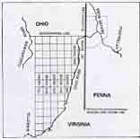
The surveys were required by the 1785 ordinance to begin "... on the Ohio River at a point that shall be found to be due north from the western termination of a line which has been run as the southern boundary of the state of Pennsylvania." This phraseology was used because the southern boundary of Pennsylvania had just been surveyed (the western terminus being marked on 16 October 1784), but the western boundary (common with Virginia) had not been surveyed, although agreement had been reached that it would be run in 1785 as a line running due north from the western terminus of the southern boundary. Thus, although not specifically so-called, it became necessary for the state line between Pennsylvania and Virginia (later West Virginia) to be run out, before the surveys of the Public Land could be started. The public domain did not include land south of the Ohio River because the Virginia cession only included land north of the Ohio River.
The survey of the Pennsylvania-Virginia line started in the first week of June 1785 under the direction of the boundary commissioners of the two states. Two of these commissioners hold honored places on the roll of distinguished surveyors - David Rittenhouse, representing Pennsylvania, scientist and instrument-maker, and Andrew Ellicott, representing Virginia, who later assisted with the layout of the District of Columbia and other important boundary surveys. The line was run due north with a "Transit Instrument", oriented by means of observations on Polaris and other stars. This line was completed on 20 August 1785, when the boundary surveyors "...set a stake on the flat, the north side of the River (Ohio)." Thus was set the mark for the "point of beginning" of the survey of the Public Lands, although it should be remembered that this survey (the line between Pennsylvania and Virginia) was not performed for the Public Land Survey, but was a joint action of the two states involved. However, the Ordinance of 1785 required that the Public Land Surveys were to begin at a point to be located in accordance with the plans for the boundary survey.
The Ordinance of 1785 and supplementary instructions from Congress required that the Public Land Surveys were to be made under the personal supervision of the Geographer (of the United States), a Congressional appointee. This position was held by Thomas Hutchins, who was supposed to be assisted by thirteen surveyors, one from each of the states, but, when work was started only eight were on hand. The group assembled at Pittsburgh early in September 1785 and proceeded to the "point of beginning" just marked on 20 August 1785, where they commenced work on the Public Land Surveys on 30 September 1785. The instructions required the Geographer to run a line west from the point of beginning, and, as each six-mile length was accomplished, one of the other surveyors was to commence running a line due south, for a range of townships, stopping when he came to the Ohio River. The beginning was inauspicious because only about four miles were run because the Geographer received word that he would be attacked by Indians and he suspended operations. Nevertheless, this start signaled the commencement of the Public Land Surveys and the line here started and extended in the next year has become known as the "Geographer's Line" and is the northern boundary of the first group of townships laid out under the Public Land System. This group of townships has become known as the "Old Seven Ranges". It might be interesting to note that the first surveyor to lay out a township line south of the Geographer's Line was Absalom Martin of New Jersey who, in August 1786, six miles west of the "point of beginning", started south on the survey of the First Range.
In attempting to re-establish the location of the Point of Beginning in 1960, for the purpose of perpetuating its location, and for a ceremony to take note of the 175th Anniversary of the U. S. Public Land Surveys, several difficulties arose. First, it became obvious that the location of the point was not suitable for monumentation because it was in an active, expanding slag dump. Second, its location was not permanently marked in 1785, the notes of that day simply stating "set a stake..." However, in inspecting the site it became obvious that another important survey was in danger of being obliterated. The 1785 survey of the Pennsylvania-Virginia line terminated at the north shore of the Ohio River, but was continued north, at first continuing underthe supervision of Andrew Ellicott (hence, the line between Pennsylvania and Ohio has become known as "Ellicott's Line") being completed to the shore of Lake Erie in 1786. This line became largely obliterated with time, and, during the period 1878-1882, it was resurveyed (known as the 1881 survey). At the time of this resurvey a large carved granite monument was placed at the base of the slope rising from the Ohio River. This monument, called the "Southern Terminal Monument", was also (in 1960) located in the midst of the slag dump and was in imminent danger of being destroyed orburied under many feet of dumped slag. It should be noted that this monument was placed in 1881 at a point considered conveniently near the southern end of the line but was not intended to mark (or bear any fixed relation to) the "Point of Beginning".
However, the Point of Beginning was originally set by a survey to mark the state line of Pennsylvania, and the 1881 monument was intended to re-mark the line according to the best available evidence. Hence, the operation to monument the Point of Beginning was merged with an operation to preserve the 1881 monument and the state line.
First, the state line was run north to the next point on the 1881 survey. Next, the Geographer's Line, as indicated by several accepted marks on the north line of Township 5 North, Range I West, in the Town of East Liverpool, Ohio, was extended east to intersect the Ohio-Pennsylvania line of 1881, re-establishing, according to the best evidence, the position of the Point of Beginning. The distance along the boundary line from the Southern Terminal Monument to the Point of Beginning was thus obtained. Then a new location for the Southern Terminal Monument was selected, north of its original location, on the surveyed Ohio-Pennsylvania line, at the south edge of the highway, on land donated by the Youngstown Sheet and Tube Company, owners of the land on both sides of the original location of the monument. The land has been developed into a roadside park by the Pennsylvania Highway Department and the original Southern Terminal Monument moved to its new location. It now continues, safe in its new location, to mark the Ohio-Pennsylvania line, and, simultaneously serves as a witness to the original location of the Point of Beginning of the U. S. Public Land Surveys. A new inscription, carved on a blank face of the monument, indicates that it is 1,112 feet from the Point of Beginning. It was moved 421.54 feet north from its original location.